Explore 30 days of seismic activity world-wide in the map and timeline. Browse quakes by time and magnitude. Spotlight specific quakes with a touch.
 notification tab
Keep up to date with the latest activity with notifications, and view the latest quakes globally or regionally with the notification tab.
- Notes:
- The app updates about every 10 minutes.
- You can shake your iPad to refresh quake data on demand.
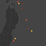
Dots mark earthquakes. Color indicates the age of a quake by week.
- this week
- 1-2 weeks ago
- 2-3 weeks ago
- 3-4 weeks ago
- youngest highlighted
- oldest highlighted
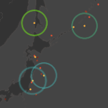
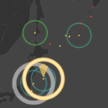
Highlighted quakes are bounded by colored rings. Ring size indicates magnitude. Ring color varies to distinguish a quake's age relative to the other highlighted quakes. The highlight selection box defines the range of time and magnitude highlighted from the timeline.
 spotlighted quakes
The map, timeline and the highlight box adjust to center on quakes you spotlight by tapping them or dragging the spotlight cursor.
- Tips
- The map scrolls freely across the dateline.
- It is embedded with the app and can be viewed while offline.
- It is limited to a zoom level of 8.
- Rest a finger on a highlighted earthquake in the map then glide to any other highlighted earthquake to browse their details.
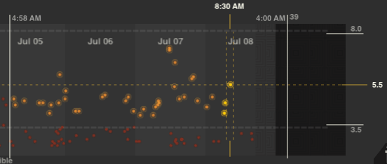
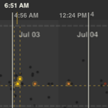
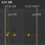
The timeline plots quakes by time and magnitude and distinquishes which quakes in the timeline are visible in the current map view. Black dots indicate quakes that are currently out of view of the map. Red dots indicate quakes that are visible in the map. Ringed dots identify highlighted quakes.
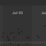
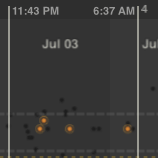
- visible in map
- out of view
- highlighted
The highlight selection box floats over the timeline, selecting the quakes from the timeline that fall inside its boundries. Over both, floats the spotlight crosshair.
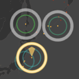
The spotlight crosshair identifies a specific quake selected from the map or timeline and can be dragged to browse highlighted quakes in time and by magnitude.
- Tips
- The selection box adjusts to bound quakes you tap in the timeline
- You scroll the timeline by dragging the timeline background.
- The timeline has 3 levels of time detail. Double tap on the timeline background to zoom in. Tap once with two fingers to zoom out.
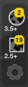
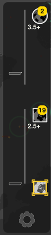
Tap  to view the latest quakes globally.
The map will zoom out to a global view, and adjust timeline to show the latest quakes that are at and above the global magnitude threshold
(3.5+ in this example). The badge value ('2' in this example) indicates the number of quakes that have occured since the last update.
to view the latest quakes globally.
The map will zoom out to a global view, and adjust timeline to show the latest quakes that are at and above the global magnitude threshold
(3.5+ in this example). The badge value ('2' in this example) indicates the number of quakes that have occured since the last update.
The global threshold is set in notification preferences.
Tap  to view the latest quakes by region.
The map will zoom to the currently defined notification region, and adjust timeline to show the latest quakes that are at and above
the regional magnitude threshold (2.5+ in this example).
The badge value ('19' in this example) indicates the number of quakes that have occured in the region since the last update.
to view the latest quakes by region.
The map will zoom to the currently defined notification region, and adjust timeline to show the latest quakes that are at and above
the regional magnitude threshold (2.5+ in this example).
The badge value ('19' in this example) indicates the number of quakes that have occured in the region since the last update.
The region threshold and region is set in notification preferences.
To change notification preferences tap 
The notification tab will expand to expose the preference controls.
Over the map, orange brackets will appear which indicate the map area that will define the notification region. These
brackets change size depending on the map area viewed.
The sliders set the viewing/notification threshold magnitude. To turn off global or regional notifications, push the appropriate slider to the top.
To set the region of interest, navigate to the map area you are interested in and position and scale the map so your area of interest fits within the orange brackets.
Tap  to set the region.
You can verify the area covered by tapping
to set the region.
You can verify the area covered by tapping
Tap to close the controls and
update the notification server with your settings.
The app updates quakes when you close preference controls.
 magnitude rings
The selection box highlights quakes from the timeline which lie inside its boundries. Highlighted quakes are displayed with magnitude rings in the map. Drag the highlight border lines to specify the magnitude and time range you like.
The highlight box will adjust to center around quakes you spotlight.
- Tips
- Only visible quakes are highlighted in the timeline. To highlight an out of view quake, tap on the quake in the timeline or zoom the map out. The right hand time boundry displays the number of the quakes highlighted ('39' after 4:00am).


The spotlight crosshair identifies the specific quake selected in the map or timeline. The crosshair also spotlights quakes that occured around the same time, or are of the same magnitude as the selected quake. You can specify spotlight 'by time' or 'by magnitude'.
To spotlight earthquakes around the same time as the selected quake, tap 
To spotlight earthquakes of the same magnitude as the selected quake, tap 
- Tips
- Drag the crosshair by its center to browse time and magnitude simultaneously.
- Drag the crosshair by the dashed lines to scroll specifically by time or by magnitude.
- Drag the crosshair center outside the highlight area to supress spotlighting.

When sound is enabled, a short sound plays when a quake is spotlighted. Unique sounds are assigned to each whole magnitude on the Richter scale, up to and including magnitude 8.0.
- Tips
- Timeline scrolling is slightly smoother when quake sounds are muted.